


Drones, Wither Goest?

April 13, 2015

Written by Editor

header

If something is really important you need more than one. You don’t need to have a degree in safety or systems engineering to know that.

A Washington Post report last year showed that large autonomous aircraft are particularly vulnerable to GNSS as a single point of failure:

“Unreliable communications links. Drones are dependent on wireless transmissions to relay commands and navigational information, usually via satellite. Those connections can be fragile. Records show that links were disrupted or lost in more than a quarter of the worst crashes.”

Down on the ground, most makers of autonomous vehicles have taken the point and, while using GNSS as one sensor, are relying upon Lidar, high precision maps, cameras, and other on-board sensors to keep their vehicles and passengers safe.

Such techniques are not possible or readily applicable for maritime, submarine, and low-flying aviation operations, though. And even for some terrestrial operations where GNSS augmentation could be possible, such as automated cargo cranes and power grid synchronization, many still do not see the necessity to make the effort.

Ramsey Faragher, Senior Research Associate at University of Cambridge and Bye Fellow of Queens’ College, Cambridge, likes to point out that God gave us five senses to find our way in the world. Why do most people think it’s OK to have our technology rely just on satellite navigation to do the same thing?
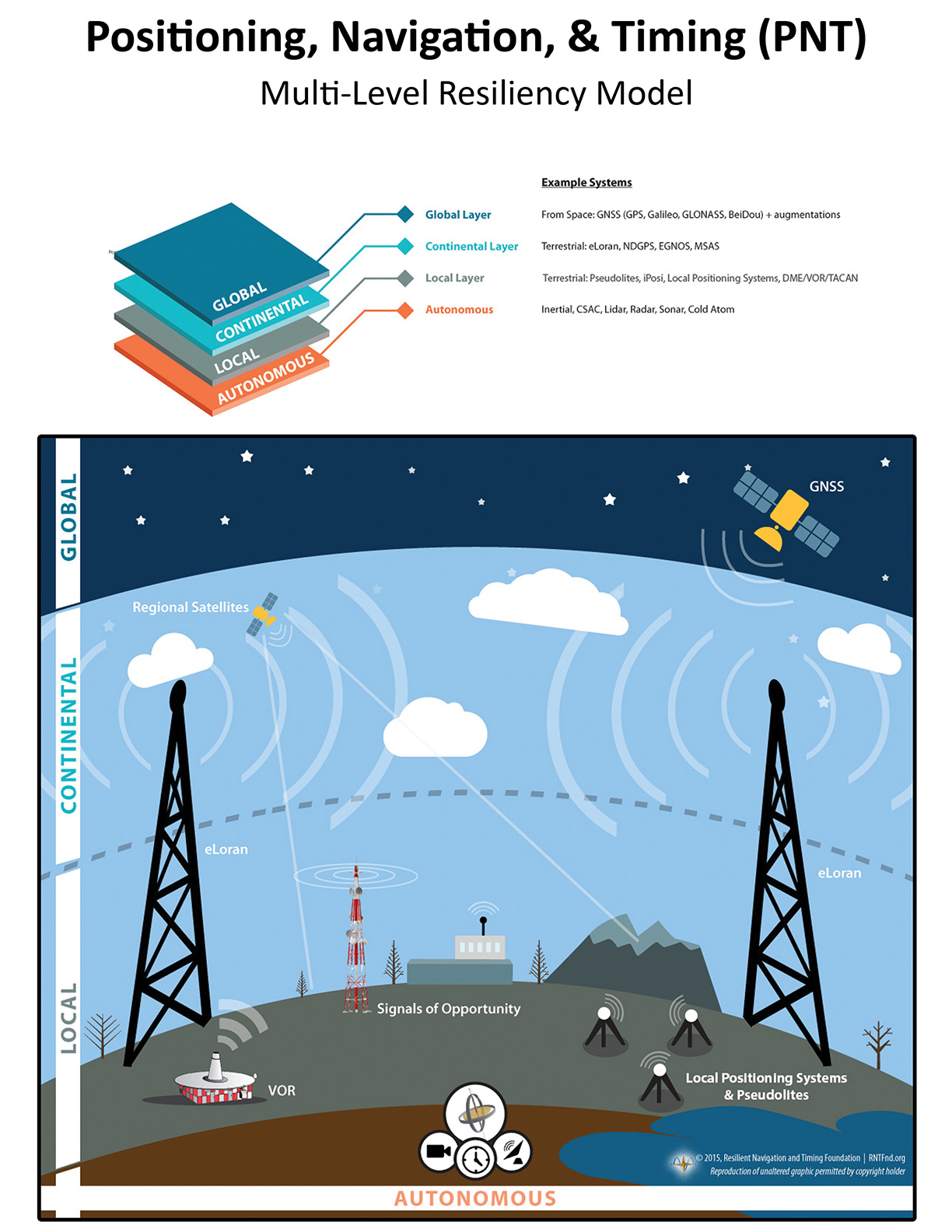
This graphic shows the RNT Foundation’s vision for a multi-level, resilient navigation and timing ecosystem. It is available for download here. Help yourself to it, and help us spread the word.

Also, if you think this is an important issue, the federal government has two initiatives you should weigh in on.

The first is a request for public comment from the Department of Transportation as to whether folks would use an eLoran system, and what their requirements might be.

The second, is a bill in Congress that would require establishment of a terrestrial system to be a complement to and backup for GPS.

Make yourself be heard!

What Can YOU Do? How Can YOU Help?

PNT is the quiet backbone of everything but too many leaders still don’t see the risk.

But you do. You understand the systems, the dependencies, the failure chains. That insight is rare — and it’s exactly what your country needs right now. Contact your government leaders and industry decision-makers and tell them resilient PNT isn’t a feature — it’s the foundation everything else depends on.

Start the Conversation

Use our Resilient PNT Key Talking Points to make the case.

U.S. Advocates

Find your representatives at Congress.gov, then use our email template to reach them in minutes.

When you get a response, let us know. Every conversation strengthens the mission.

More PNT News

US Congress hearing on PNT –  June 4th

US Congress hearing on PNT – June 4th

Image credit: House Energy and Commerce Committee What's new: A congressional hearing titled Where Are We?: Examining Positioning, Navigation, and Timing Capabilities in the United States. Why it's important:  The hearing is being held by the Communications and...

GPS NOTAMS Not Enough for Safety – Jeremy Bennington at Spirent

GPS NOTAMS Not Enough for Safety – Jeremy Bennington at Spirent

Image: Jeremy Bennington What's new: An important opinion piece on LinkedIn by RNTF member Jeremy Bennington at Spirent about intentional GPS disruption and aviation safety. Why it's important: People's lives are at stake. False contacts, bad locations, relying on...

UK Defence Minister’s Aircraft Jammed… Again – BBC

UK Defence Minister’s Aircraft Jammed… Again – BBC

Image: GPSJam.org - Jamming in the Baltic the day of the minister's flight What's new: The aircraft carrying another high ranking official experienced jamming in northern Europe. Why it's important: Even though jamming impacts tens of thousands of ordinary people on...

UK maritime navigation leader on chokepoints – PoliticsHome

UK maritime navigation leader on chokepoints – PoliticsHome

Image: UK General Lighthouse Authority - 28 days of ship traffic in Dover Strait What's new: An opinion piece from the head of the UK's General Lighthouse Authority which is responsible for maritime aids to navigation and assists government in marine spatial planning....

Get PNT News in Your Inbox