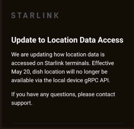
,Is,A")
Image: Shutterstock
The late Ashton Carter was Secretary of Defense from 2015 to 2017. In a 2014 interview while he was awaiting confirmation he was quoted as saying:
“I hate GPS …Twenty years from now everything … will have on the chip a clock, a gyro and an accelerometer. … it will forever know what time it is, where it is, what its spatial orientation is. And it will never need a satellite.”
Independent time (clocks) and navigation (inertials) systems have some great uses and applications.
Eleven years into Ashton Carter’s 20 year prediction, here is a summary of the state of the art for inertial sensors, courtesy of Talladega Systems, Inc.
🚀 Modern INS Technologies: Overview & Stats
| INS Type | Technology | Typical Drift Rate (°/hr) | CEP/hour (w/o GPS) | Use Cases |
| MEMS (Micro-Electro-Mechanical Systems) | Tiny capacitive sensors | 1–1000 °/hr | 100s of meters to >10 km | Drones, cars, handheld devices |
| FOG (Fiber Optic Gyroscope) | Laser phase shift in fiber coils | 0.01–1 °/hr | ~10–100 m | Aircraft, ships, UAVs, tactical missiles |
| RLG (Ring Laser Gyroscope) | Laser interference in triangular cavity | 0.001–0.01 °/hr | ~1–10 m | Commercial airliners, spacecraft, ICBMs |
| HRG (Hemispherical Resonator Gyro) | Vibrating quartz or shell | <0.005 °/hr | ~1 m or better | Strategic missiles, submarines |
| Quantum (cold-atom, optical lattice) | Atom interferometry | <0.0001 °/hr (theoretical) | <1 m / week | Deep space, future strategic systems |
🔍 Key Metrics
1. Drift Rate (Bias Stability in °/hr)
How much the system “drifts” due to gyroscope error if left unaided.
- Consumer MEMS: 10–1000 °/hr (i.e., unusable after minutes without GPS)
- Tactical-grade FOG: 0.1–1 °/hr
- Navigation-grade RLG/FOG: 0.01–0.001 °/hr
- Strategic/Space-grade HRG/FOG: <0.001 °/hr
- Quantum: approaching 0.00001 °/hr, but still experimental
2. Position Error Growth (CEP)
How far off the position estimate will be over time without updates:
| Time | Consumer MEMS | Tactical FOG | Navigation RLG | Quantum INS |
| 10 min | ~1–5 km | 100–500 m | 10–50 m | <1 m |
| 1 hr | >10 km | 1–5 km | 100–300 m | <10 m |
| 24 hr | N/A (unusable) | >100 km | 1–3 km | <100 m |
⚠️ Most modern systems are hybridized with GPS, magnetometers, barometers, or visual SLAM to limit error growth.
📦 Examples of Modern INS Systems
🔸 KVH CG-5100 FOG INS
- Type: Navigation-grade FOG
- Drift: ~0.01 °/hr
- CEP/hour: ~10–30 meters
- Use: Maritime navigation, aerial survey, UAVs
🔸 Honeywell HGuide n580
- Type: MEMS INS with GNSS
- Drift (w/o GNSS): ~1 °/hr
- Position Error (1 hr): ~1–3 km
- Use: Precision agriculture, construction equipment
🔸 Northrop Grumman LN-270
- Type: RLG INS with GPS-aiding
- Drift: <0.003 °/hr
- CEP/hour: ~10 m (unaided)
- Use: Military aircraft, naval ships
🔸 iXblue MARINS M7
- Type: FOG-based INS
- Drift: 0.001 °/hr (strategic-grade)
- CEP/hour: ~2–10 meters
- Use: Submarines, autonomous vessels
🧪 Emerging Tech: Quantum Inertial Navigation
- Principle: Atom interferometry measures acceleration and rotation from atomic phase shifts.
- Performance: Projected bias drift <0.0001 °/hr
- Vendors: ColdQuanta, Thales, Northrop Grumman, UK DSTL, Honeywell
- Status: Lab use / strategic defense; not yet commercial
🧠 Summary Table
| Grade | Drift (°/hr) | Position Error/hr | Size/Cost | Use Case |
| Consumer MEMS | 10–1000 | >10 km | cm / <$100 | Phones, drones |
| Tactical MEMS/FOG | 0.1–10 | 100 m–1 km | small / $1k–$10k | UAVs, AGVs, missiles |
| Navigation RLG/FOG | 0.001–0.1 | ~10–300 m | rack / $20k–$100k | Aircraft, ships |
| Strategic HRG/FOG | <0.001 | ~1–10 m | large / $200k+ | Submarines, ICBMs |
| Quantum | <0.0001 | <1 m (week) | emerging | GPS-denied, space |