Image: Copilot AI
What’s new: A South Korean government press release about a two day meeting with the U.K. and France. Among the discussion items were:
- Strategic plans to standardize eLoran, and
- Establishing an international consultative body for eLoran cooperation.
Why it’s important: For the technology to be as useful as possible in transportation and across infrastructures, standardization must be carefully managed, as is the case with GNSS.
What else to know:
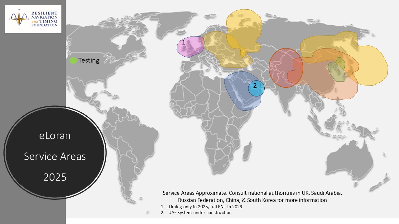
- In the 1990’s Loran-C was used in the U.S. by aviation and maritime for navigation, and by many telecommunication and financial companies for timing.
- The U.K. has only one transmitter on line, but is slated to have a total of six.
- France has announced it will partner with the U.K. on eLoran for northern Europe.
- The U.S. military has three transmitters on line in the northwest part of the nation.
- Government and quasi-government organizations that formerly helped standardize Loran operations included:
- Far East Radio Navigation Service (FERNS) led by S. Korea with members U.S., Russia, China, and Japan. The U.S. and others held observer status.
- The UK’s General Lighthouse Authority Research and Development (GRAD)
- The U.S. Coast Guard Navigation Center
- International Association of Lighthouse Authorities
- Non-profit organizations that formerly helped standardize Loran operations included the International Loran Association, Institute of Navigation, and Royal Institute of Navigation.
![]()
2025-11-11 | Press Release | Ministry of Oceans and Fisheries
Strengthening International Cooperation on Long-Range Navigation to Overcome GPS Jamming
– Discussions on policy and technology cooperation in terrestrial navigation with the UK and France in Seoul beginning November 11
The Ministry of Oceans and Fisheries (MOF; Minister Chun Jae-soo) announced that it would be holding a meeting of the standardization working group for the terrestrial navigation service (eLoran)* with the UK and France in Hotel Koreana, Seoul from Tuesday, November 11 to Wednesday, November 12. The eLoran system can provide stable location, navigation, and time information even in GPS radio jamming situations.
* enhanced Long-range navigation: A terrestrial navigation system that calculates location by measuring the arrival time of radio waves (100 kHz) transmitted from three or more ground-based transmitters
eLoran has attracted attention as a navigation system that complements GPS since it is not affected by satellite signal interference and it uses a high-power, low-frequency signal and provides high location accuracy within 20 meters, plus it can provide precise timing information up to 1/1,000,000 of a second (10-7 seconds).
This first-ever meeting will be attended by 30 experts from various countries, including representatives from three countries: Republic of Korea, United Kingdom, and France. They will share the latest policy and technology development trends in the eLoran field and discuss key agenda items, including:
▲ Strategic plans to standardize eLoran, and
▲ Measures to establish a consultative body for international eLoran cooperation and regular meetings.
MOF plans to introduce ROK’s eLoran system—built primarily in the West Sea—to counter GPS signal interference and to demonstrate the service directly at Incheon Port, which is expected to garner great interest from participating countries.
Through this meeting, the Ministry plans to strengthen cooperation in the field of alternative navigation system technology and—based on this—enhance the capability of ROK’s satellite navigation system to withstand GPS signal jamming and improve maritime safety.
“We expect this first meeting to be an important starting point for international cooperation in the field of eLoran. We will do our best to lead the way in international standards for eLoran and expand cooperation with major countries to establish a navigation system that will prepare against GPS signal jamming,” said Choi Seong-yong, Director General of MOF’s Maritime Safety Bureau.
Dr Mark Brammer, UK Positioning Programme Lead from the National PNT Office concurred with the Director General and noted that “the experience and expertise of the Republic of Korea, United Kingdom and France in developing and operating eLoran and other navigation technologies is the ideal starting point for adoption and interoperability standards across the globe”.