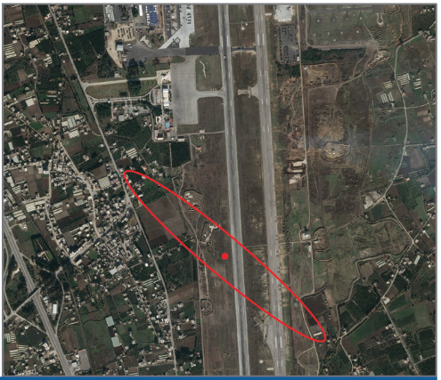
Image: University of Texas Radionavigation Laboratory
What’s New: The source of GPS/GNSS signal interference can be identified to within 100 meters by satellites in LEO.
Why It’s Important:
- Interference is bad. Messes up all kinds of things (if you didn’t know that, welcome to our site and browse around a bit for more info).
- There aren’t a lot of interference detection systems around at the moment, so it is hard to find an interference source so it can be shut off.
- Example: GPS was disrupted for 24 hours last year near Dallas-Ft Worth and air traffic was disrupted for 44 hours. The source was never located. So… could happen again from same source, we assume.
What Else to Know:
- This paper talks about locating a source within an ellipse 619m x 77m (see image above).
- We spoke with Prof. Todd Humphreys to confirm that with another satellite at a different angle you can have two ellipses with an overlap area that could be less than 100m.
- BUT:
- Satellites have to be available and tasked
- The information has to go to someone who cares and is willing to act.
- That someone has to have the legal authority and operational capability to stop the interference.

Dual-Satellite Geolocation of Terrestrial GNSS
Jammers from Low Earth Orbit
Abstract—This paper explores two-step and direct geolocation
of terrestrial Global Navigation Satellite System (GNSS) jammers
from Low Earth Orbit (LEO). Within the past decade, there
has been a sharp increase in GNSS outages due to deliberate
GNSS jamming. Receivers in LEO are uniquely situated to
detect, classify, and geolocate terrestrial GNSS jammers. The
conventional two-step geolocation method first estimates the
differential delay and differential Doppler, then uses a time
history of these to estimate the transmitter location. By contrast,
direct geolocation is a single-step search over a geographical grid
that enables estimation of the transmitter location directly from
the observed signals. Signals from narrowband, matched-code,
and chirp jammers recently captured in the GNSS frequency
bands by two time-synchronized LEO receivers over the Eastern
Mediterranean are analyzed and the emitters geolocated. It is
demonstrated that the direct approach is effective even for low
signal-to-noise ratio interference signals based on short captures
with multiple emitters. Moreover, the direct approach enables
geolocation of multiple emitters with cyclostationary signals (e.g.,
chirp jammers), whereas the two-step method struggles in such
cases to associate emitters with their corresponding structures in
differential delay and Doppler space.


