Hover over objects and people in the illustration below to find out how GPS affects every corner of daily life.
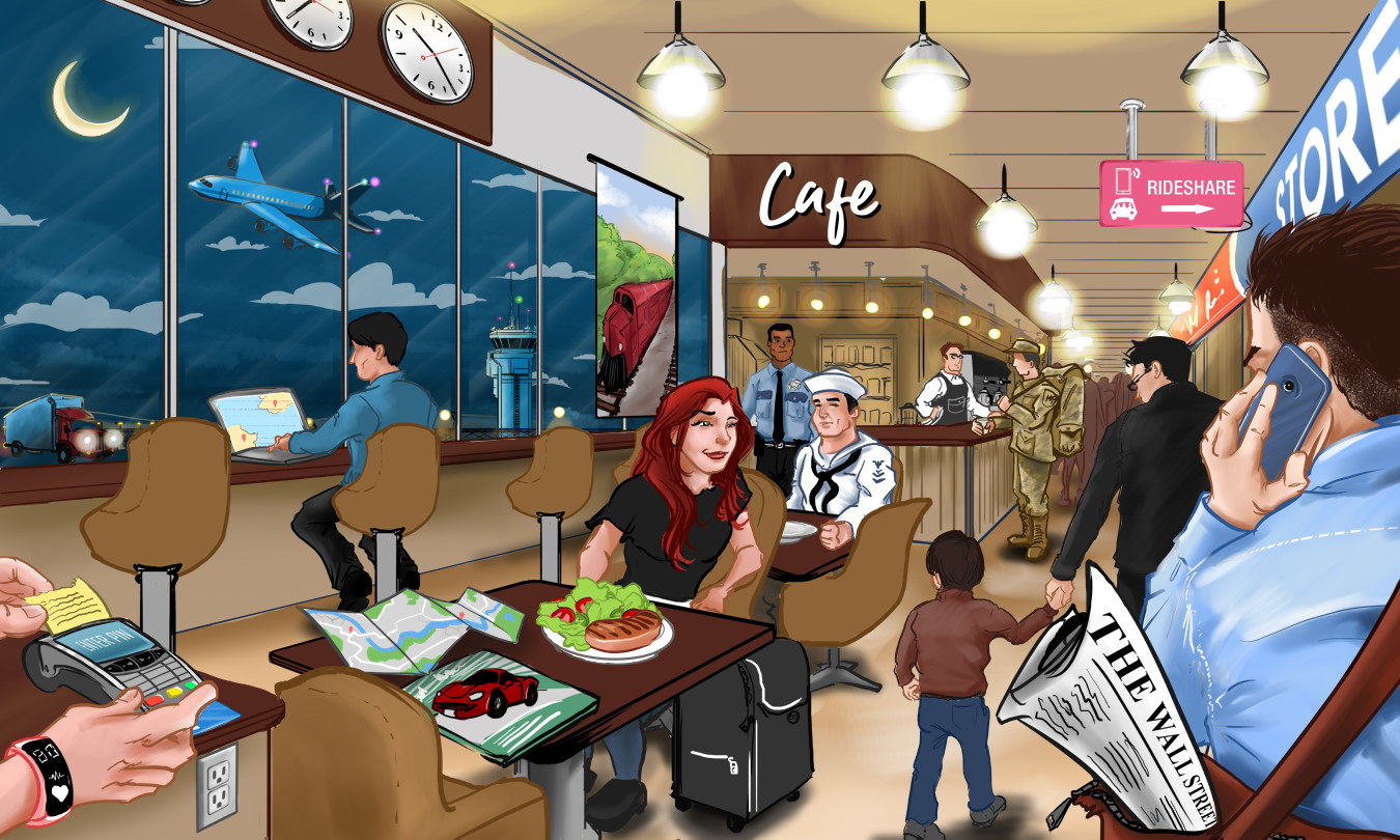
Tap one of the links below the the illustration to see how GPS affects our daily life.
Electric Outlet & Lights – GPS timing and synchronization are important to management of electrical grids. They ensure smooth power sharing between grids and are used in control systems. GPS is used in at least 10 different ways to safely and efficiently deliver electricity.
PNT ADVISORY BOARD ON CRITICAL INFRASTRUCTURERNTF ON SMART GRID & ELECTRICAL POWERReturn to Top
PNT ADVISORY BOARD ON CRITICAL INFRASTRUCTURERNTF ON SMART GRID & ELECTRICAL POWERReturn to Top
Café & Plate with food – GPS is essential for modern agriculture and food production. Precision farming using augmented GPS has been developed that uses only a fraction of the fertilizer, fuel, pesticide, and manpower that was previously needed. GPS enabled tracking helps keep livestock and pastures healthy. Because of GPS , more food is produced and it is less expensive. Farmers, the environment and consumers all benefit. PNT ADVISORY BOARD ON AGRICULTURE GPS.GOV ON AGRICULTUREReturn to Top
Truck – Accurate and efficient navigation enabled by GPS is exceptionally important for all modes of transportation including trucking. GPS enables a wide variety of applications including fleet management, cargo tracking, delivery route optimization, and synchronization of traffic lights. GPS and complementary technologies are essential to safe operation of autonomous vehicles and intelligent transportation systems. PNT ADVISORY BOARD ON TRANSPORTATION RNTF PAPER ON TRANSPORTATION GPS.GOV GPS & ROADS RNTF PAGE ON DRONES & UNMANNED SYSTEMSReturn to Top
Airplane & Control Tower – While aircraft are also able to navigate using a network of terrestrial beacons, the preferred and most efficient method is using GPS. It enables point to point navigation using the minimum amount of time and fuel. GPS also enables the ADS-B aviation safety system that tracks aircraft and helps avoid collisions. A large number of in-cockpit and air traffic control services also use GPS signals. GPS and complementary technologies are essential to safe operation of autonomous vehicles like airborne drones, and intelligent transportation systems. PNT ADVISORY BOARD ON AVIATION GPS.GOV ON AVIATION RNTF ON DRONESReturn to Top
Moon - GPS is revolutionizing and revitalizing the way nations operate in space, from guidance systems for crewed vehicles to the management, tracking, and control of communication satellite constellations, to monitoring the Earth from space. NASA is even looking at how it can use GPS to help navigate back to the moon. GPS.GOV ON SPACE APPLICATIONS
Clouds - Many people are surprised to learn that GPS signals are used in forecasting the weather and to protect the environment. Air temperature, moisture, and pressure have very slight, but detectable, influences on GPS signals. Meteorologists often measure these to help predict the weather and will be doing so increasingly in the future. PNT ADVISORY BOARD ON SCIENCE WIRED MAGAZINE ARTICLE ON GPS & WEATHER GPS.GOV ON GPS & ENVIRONMENTReturn to Top
Wall Street Journal & Credit Card machine - Financial systems use precise time from GPS to time stamp transactions, ensure they are synchronized with markets opening and closing, and to optimize their networks. In financial hubs such as downtown New York and Chicago, many financial services firms have established dedicated timing suites (clocks, fiber, dedicated circuits) to augment GPS signals to service areas in the vicinity of exchanges and trading houses. Retail financial services across the country (consumer banking, credit cards, ATMs, etc.) rely upon the same network connections as other telecommunications and information technology services. These are dependent upon GPS signals for network synchronization, time stamping, etc. RNTF ON FINANCIAL SERVICESReturn to Top
Soldier – GPS was developed and maintained by the US Air Force. The Department of Defense and military services use it hundreds of ways including precise targeting, tracking forces, efficient communications, common operational pictures, and logistics. The positioning, navigation, and timing (PNT) services it provides underpins much of military technology. Military PNT Advisory BoardReturn to Top
Policeman/Security – First responders such as police, fire, EMS and Coast Guard use GPS to find the quickest ways to trouble spots, locate survivors, maintain common operating pictures, track moving objects, and resolve emergencies. GPS timing lets their radios carry multiple conversations at the same time. GPS.GOV ON PUBLIC SAFETY & DISASTER RELIEFReturn to Top
Railroad Train - Rail systems throughout the world use GPS to track the movement of locomotives, rail cars, maintenance vehicles, and wayside equipment in real time. When combined with other sensors, computers, and communications systems, GPS improves rail safety, security, and operational effectiveness. The technology helps reduce accidents, delays, and operating costs, while increasing track capacity, customer satisfaction, and cost effectiveness. GPS.GOV ON RAILReturn to Top
Automobile – Not only does GPS help us to find our way, but when multiple users cooperate to provide traffic information, it helps us find the best way through congestion. GPS is an important sensor for assisted, automated, and autonomous driving and is a key component of intelligent transportation systems. Efficiencies in transportation due to GPS information are credited with saving billions of gallons of fuel each year. GPS.GOV ON ROADS & HIGHWAYS RNTF ON DRONES & UNMANNED SYSTEMSReturn to Top
Rideshare sign, Fitness Tracker bracelet, Child, Store – GPS enables an entire industry of "Location-Based-Services" (LBS) using mobile devices. LBS allows stores to offer coupons to consumers in their vicinity, people to monitor their fitness activity, and parents to keep track of their children. In addition to making existing businesses and activities more efficient, GPS-enabled LBS has allowed new ones to be created. Ridesharing, car sharing, bike and scooter sharing are some examples. LBS ARTICLE IN BUSINESS NEWS DAILY RNTF ON NAVIGATION & LOCATIONReturn to Top
Cell Phone – Cell phones use GPS in more ways than you might think. In addition to making phones navigation devices, GPS timing is used to synchronize networks allowing cell towers to connect with each other. The date and time on your cell phone also comes from GPS, as do the time and date tags on text messages, emails, and a variety of other applications. PNT ADVISORY BOARD ON TIMING & SYNC RNTF ON WIRELESS NETWORKSReturn to Top
Laptop Computer - GPS information is used in a variety of ways in information technology systems. Time stamping in distributed (cloud) data systems, synchronizing distributed computing, setting boundary conditions for algorithms, location data to support applications like geofencing and geoencryption, and location as a part of identity are all examples. Plus, GPS time signals are essential for wireless networks. RNTF ON GPS & ITReturn to Top
Clock – Each GPS satellite transmits a time signal precise to within 100 billionths of a second. Precise time is crucial to a variety of economic activities around the world. Communication systems, electrical power grids, and financial networks all rely on precision timing for synchronization and operational efficiency. The free availability of GPS time has enabled cost savings for companies that depend on precise time and has led to significant advances in capability. GPS.GOV ON TIMING PNT ADVISORY BOARD ON TIMING & SYNC RNTF TIMING & SYNC PAGEReturn to Top
Map - The surveying and mapping community was one of the first to take advantage of GPS because it dramatically increased productivity and resulted in more accurate and reliable data. Today, GPS is a vital part of surveying and mapping activities around the world. GPS.GOV ON SURVEYING & MAPPINGReturn to Top