



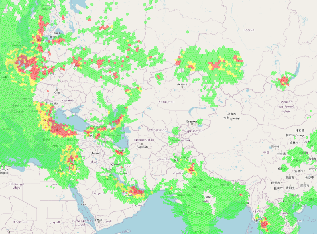
Image: GPSjam.org for 16 Aug 2026
What’s new: An insightful article that discusses misconceptions about GNSS interference detection and maps.
Why it’s important: Not understanding these issues correctly can lead to bad political, strategic, tactical, and commercial/personal decisions.
What else to know: We especially like the discussion of misconceptions:
- Misconception 1: “This is Only an Aviation Problem.”
Because interference maps use aircraft as sensors, many observers frame GNSS disruption as exclusively an aviation issue. Pilots deal with it. Airlines reroute. The narrative stops there. This framing dramatically underestimates the threat. Aviation happens to provide a convenient, global measurement network. The aircraft is a sensor platform, not the only affected domain. The National Institute of Standards and Technology (NIST) has documented critical infrastructure dependencies on GPS timing across financial services, telecommunications and electric power sectors. When aircraft detect interference at altitude, the RF environment near the source may be affecting timing servers, cellular base stations, and grid monitoring systems that lack aviation-style navigation redundancy.
- Misconception 2: ”We Are Always in Red, But Nothing Happens.”
Infrastructure operators in regions with persistent interference often observe their location marked red on these maps while their systems appear to function normally. The conclusion seems logical: either their systems are resilient, or the threat is exaggerated. Both conclusions can be wrong. The critical distinction is altitude. Aircraft observe a different RF environment than ground receivers. At cruise altitude (8,000 to 12,000 meters), an aircraft antenna has line-of-sight to interference sources over hundreds of kilometers. A ground-level timing receiver with a rooftop antenna may experience completely different conditions due to terrain, buildings and antenna orientation. GPSJAM’s own FAQ addresses this directly: “I live in a red hex and my phone GPS worked” is not a contradiction. It demonstrates that the map does not describe your personal ground-level environment.
- Misconception 3: “Planes Aren’t Crashing, So There’s No Real Danger.”
Aviation has redundancy: inertial systems, distance measuring equipment, ground-based navaids, and trained crews. When GPS fails, aircraft can typically continue safely using backup navigation. This resilience creates a dangerous inference: If aviation handles it, the threat must be manageable. The logic inverts causality. If interference is powerful enough to degrade aircraft-reported GNSS integrity at altitude (where signals from the interference source have propagated through long distances and atmospheric attenuation), then the signal power near the source at ground level may be severe. A jammer affecting aircraft at 10 km altitude is projecting substantial RF power. Ground systems in the jammer’s vicinity, particularly those without aviation-grade redundancy, face potentially greater exposure.
- The author, Maksim Barodzka and his company, GPSPatron, are members of the RNT Foundation.