Image: John Wiseman
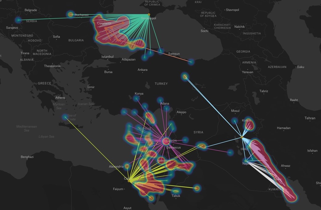
What’s New: Graphics posted on X (Twitter) by John Wiseman, the gent behind GPSJam.org.
Why It’s Important:
- The graphics show areas in the Middle East where spoofing has been occurring, and the false locations being transmitted.
- John is clearly a brilliant guy, but he has a day job and does this kind of thing as a hobby. Certainly govt authorities must be doing this kind of thing also.
- Open source information can provide insights, though one has to be careful about drawing inferences. One example of this are areas in southwest Texas that often show up on GPSJam.org. The folks at Stanford have determined that these do not indicate interference. Rather they result from military training aircraft performing aerobatics and other maneuvers that prevent them from receiving good GPS signals all the time. Their ADS-B equipment transmits a lower navigation integrity code and this is reflected on GPSJam.org’s GIS display.
What Else to Know:
- The data is from open broadcast ADS-B transmissions from aircraft. This only works if enough aircraft fly in an area of interest.
- The “spoof to” locations are likely not the locations of the transmitters. As John says “why would someone do that?”
LINK to ENTIRE THREAD HERE


John Wiseman
@lemonodor
Combined map showing areas affected by GPS spoofing in the past week, and the spoof locations. Again, I can’t detect spoofing if aircraft didn’t fly in an area, and this map doesn’t (yet) indicate where there isn’t data. But I’m pretty confident that the spoofing that is shown is real, based on my analysis of ADS-B data.