Image: National Assn of Broadcasters
Blog Editor’s Note: The interviewer for the below article is President of the RNT Foundation.

Finding your way with broadcast TV
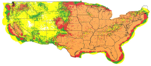
Full-power UHF TV stations in view in the continental United States: yellow (1—3 stations), green (4—6), red (7—10), orange (11 or more). (Image: NAB)
Over the years, we have seen several proposals to use television broadcasts for positioning, navigation, and timing (PNT). This idea was taken one step further in a paper by the staff of the National Association of Broadcasters (NAB). We talked with one of the authors, Robert Weller, NAB’s vice president for spectrum policy, to find out more.
Goward. Bob, your paper calls the notional system the “Broadcast Positioning System” or “BPS.” What is new about your proposal? And what led you and your colleagues to develop this idea and publish the paper?
Weller. Television broadcasters are transitioning to a new transmission standard, ATSC 3.0, that plays well with other industry protocols, has more robust operating points, stricter timing requirements, and is much more flexible. There are already more than 50 US markets with a station transmitting ATSC 3.0. Our paper began to analyze PNT in the context of ATSC 3.0 and confirmed that there was a good match. So, the idea of “broadcast positioning” was born.
Goward. In general, how would BPS work?
Weller. TV stations transmit from towers at known fixed locations. A TV station can transmit its precise location (geographic coordinates and antenna elevation) along with a time-stamp. For fixed receivers using the timing service, only one TV signal is required. Receivers would know their location a priori and would simply calculate their distance from the TV station and use that distance to determine the corresponding time that it takes for the signal to travel from the TV transmitting antenna. That time difference is then added to the received time-stamp to determine the present time at the receiver.
Both fixed and mobile users could access positioning and timing services when at least three TV stations are within range.
Goward. GPS and other GNSS are ubiquitous. What advantages do you see BPS having over space-based navigation systems?
Weller. BPS is not intended to replace GPS. BPS can provide an independent timing and/or position determination, which can provide confidence and help detect spoofing or other problems with GPS. BPS also has the advantage of high power and strong signal levels. Most UHF television stations radiate 1 megawatt of power, which does a good job penetrating buildings and is difficult to jam or spoof.
Goward. There have been many proposals for terrestrial systems to complement GPS. In general, what advantages would implementing BPS have over other non-space approaches?
Weller. There are several advantages. The cost to deploy will be less since the broadcast infrastructure is already in place. Also, because of our high power, the number of nodes necessary is fairly small. I’ll add that TV stations are built to operate 24/7, so most of them are fairly “hard” with back-up power and redundant transmitters. Additionally, the modulation and coding we propose for BPS is intended to provide service well above the noise floor, making it quite robust. Finally, low-cost receivers that are used in televisions can be used to decode the BPS information.
Goward. Your paper says that using the television stations we have today, geographically about 85% of the contiguous United States by land area would be able to get PNT services from BPS. The number is 99% for just timing services. Do you have any thoughts about those not in range for services?
Weller. Those percentages were intended to be conservative and only considered full-power UHF TV stations. There are also hundreds of VHF stations and thousands of low-power TV stations. If you include those stations, the coverage percentages are even higher. It’s certainly possible to add more stations if needed to reach the most remote and unpopulated parts of the United States.
Goward. What about user equipment? Have you done any work in that area? How small do you think receivers could be eventually?
Weller. There are compact GPS and LORAN receivers out there, and the technology for BPS isn’t much different. Some Korean companies have already built very small ATSC 3.0 receivers to carry RTK corrections to GPS for use in drones. There are also already ATSC 3.0 USB receivers that weigh less than an ounce.
Goward. Are there other services that BPS could provide?
Weller. BPS can be one element of a PNT system-of-systems that also improves other PNT services. In my opinion, the most valuable service BPS can provide is an alternative reference for critical infrastructure if GPS is compromised. However, BPS would occupy a tiny fraction of ATSC 3.0 signal capacity. So, there could be additional services such as transmitting ephemeris data for expedited GPS acquisition, RTK data for improved PNT accuracy, or even map information.
Goward. Have you thought about what you would be using as a time source?
Weller. Most TV stations already have GPS, but since the point of BPS is to provide redundancy and resilience to GPS, we’re looking at cesium clocks, optical fiber, and eLORAN as possibilities.
Goward. NAB is a trade association. How do you see this project benefiting your members?
Weller. This project affirms the public service mission of broadcasters as well as our designation as critical infrastructure. If broadcasters are compensated for the equipment and resources required for deploying and operating BPS as a public service, I expect high participation and user adoption.
Goward. Where do you think you and your colleagues will take the project from here?
Weller. We’re working with possible users to determine their requirements while also trying to identify funding sources to enable the development. We hope to build prototypes and launch market trials as next steps towards commercialization.