![]()
Vulnerabilities of GPS is a big concern: Dana Goward
Satellite systems have become an integral part of our businesses for precise navigation and timing services. Yet GPS/GNSS jamming, spoofing, and other forms of interference appear to be growing in frequency and severity. Recently, the Senate Armed Services Committee (SASC) asked Pentagon to provide Combatant Commander’s alternate position, navigation and timing (PNT) systems to GPS within two years.

We caught up with Dana Goward, a member of the National PNT Advisory Board, and President & Director of RNT Foundation, an independent, member-supported non-profit that works in the area building awareness about the importance and vulnerabilities of navigation and timing systems, encourages development and implementation of resilient terrestrial systems, and advocates for policies to deter spoofing and jamming. Goward is retired from the federal Senior Executive Service having served as the maritime navigation authority for the United States. He has represented the US at IMO, IALA, the UN anti-piracy working group, and other international forums. He is also a Senior Adviser to Space Command’s Purposeful Interference Response Team.
Why is there so much concern around vulnerabilities of GPS?
It’s not just about GPS; all GNSS signals are weak. They are 20,000 km above the Earth, powered by solar panels, and are transmitting all the time, after all. Just as a matter of physics, it’s very easy to block a relatively weak signal. That is what GPS jamming is. Also, because the different global navigation satellites systems want to increase their user base, they release all the information about their signals so they can be integrated into other systems. But if you know exactly what the signals look like, you know how to imitate them. This makes the signals open to spoofing as well. That is another significant challenge, because, in many ways spoofing is worse than jamming — instead of no information, spoofing can give you hazardously misleading information.
ALSO READ: Why Resilient PNT Infrastructure is Imperative to Global Economic Growth
All GNSS are relatively the same signal strength and in same general frequency band, and they are all in space. Naturally, they are subjected to same kind of vulnerabilities — severe solar activity, malicious high-power electro-magnetic pulses, local jamming, spoofing, etc. Even urban canyons and downtown cities are a challenge as the signals tend to bounce off buildings and can cause problems for receivers. Using multiple GNSS systems at the same time does protect users a bit if one of the systems suffers a cyberattack or an equipment failure. So, it does offer some measure of additional resilience. But, generally, they all have similar vulnerabilities and are subject to the same threats, so the added resilience and security is marginal.
These shared vulnerabilities have been a concern for some time. There are all kinds of incentives for individuals and organizations to interfere with GPS signals — from delivery drivers taking long breaks, to criminal organizations wanting to divert a shipment, to nations looking to counter the armed forces of another. For example, American generals have said that Syria and the Middle East have the highest intensity of electronic warfare anywhere on the face of the planet. A lot of that is GPS/GNSS jamming and spoofing.
Interestingly, a recent sampling by the European Union found 500,000 instances of transmissions on GNSS frequency that should not have been there. About 10% of them were determined to be malicious and intentional, while the others were just apparently accidental. So, there are a lot of vulnerabilities in the system, and a lot of real-world threats
From cellular networks to power grids to transport systems, GNSS is the source of accurate, synchronized time for almost everything. A 2012 Boston Consulting Group study found that the geospatial services fueled by GPS resulted in $1.4 trillion a year in savings to the US economy and another $1.6 trillion in added revenues. A London Economics study found that if GPS/GNSS went away for five days, the UK economy would suffer losses of £5.2 billion, which translates to $482 billion per year.
We are fortunate that nothing really bad has happened so far. At the RNT Foundation we encourage responsible governments to try to get ahead of things and prevent mishaps, rather than waiting for them to happen before swinging into action.
Tell us about the details of the FCC-Ligado controversy?
Ligado is really an interesting case. Ligado Networks, an American satellite communications company, claims they want to establish a low-power nationwide 5G network. And it has been allotted space in the L-band spectrum which is the same band as that of GPS and other GNSS. US government tests have shown that these transmissions will interfere with GPS reception for many users. Naturally, a lot of organizations and individuals, including the Executive branch of the government, are concerned about its possible impact on GPS and are of the opinion that we shouldn’t go ahead with this. However, the Federal Communications Commission, which is an independent agency and works on its own under a congressional mandate, is convinced that this isn’t going to be that much of a problem, approved the request, and is refusing to budge.
Ever since, the opposition to the proposal has been growing. The entire executive branch of the government, including the Department of Defense and Department of Transportation, have amplified their protest and a number of organizations including the RNT Foundation, have formerly requested that the FCC reconsider their decision. Now, there is some legislation in Congress to examine the decision. The end of that story is yet to be written.
One of my thoughts here is that the FCC is the ‘communications’ commission, not the ‘navigation’ or ‘geospatial’ commission. Radio communications are different from radio navigation in a lot of ways. In fact, they are almost opposites — in radio communications you are blasting the 1s and 0s through the surrounding noise to get the message through, while in radio navigation you look down within the background noise for the 1s and 0s. And rather than identifying the 1s and 0s as the message in communications, radio navigation precisely measures the time of the change from a 1 to a 0 so the receiver can figure out its location. There are a bunch of other differences as well.
It could well be that the radio and communications engineers at FCC didn’t have the right context to evaluate the Ligado proposal as it would affect navigation. As an example — I was on a panel with the head of Ligado who is a communications engineer. I said there were tests that found Ligado transmissions violated the government safety buffer for GPS failures. I said that, rather than using the safety buffer in its tests, Ligado had tested the GPS receivers to the point of failure. Ligado’s CEO replied that they hadn’t done that. They had just tested the receivers to where they started “giving bad information.” OK, so that’s worse. Bad information is worse than no information at all.
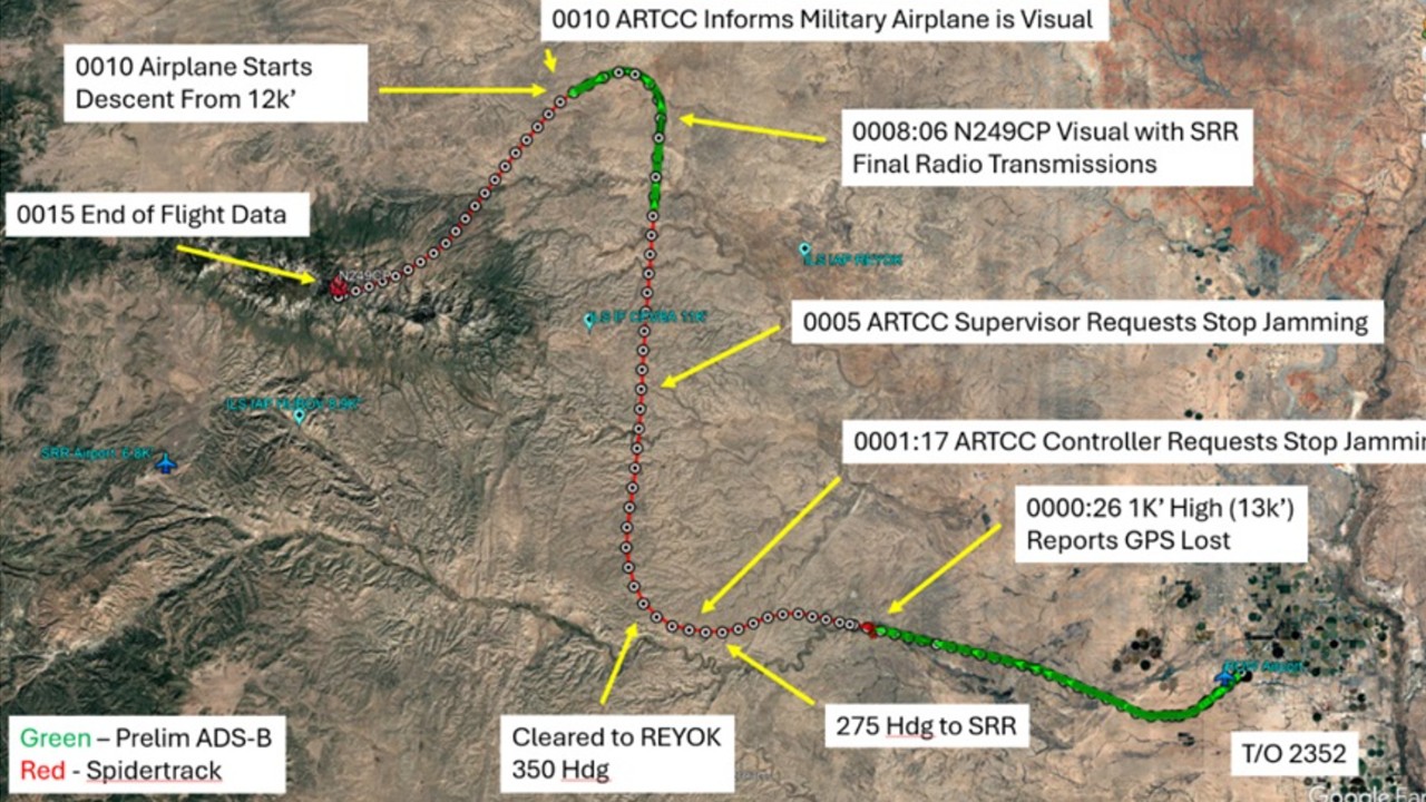
But it shows the difference between the way communications engineers and navigation engineers view things. In communications, a little bit of interference might not be so bad. You could probably understand the overall message. Or, if it is two-way communications, you could ask for a repeat. Not so for navigation. One of the first signs of interference with GPS/GNSS signals in many receivers is bad, potentially hazardous, information. A safety report to NASA last year detailed how a passenger aircraft nearly crashed into a mountain because of this kind of interference with its GPS receiver.